Saratoga National Historic Park
We’ve visited a couple of times in the last few years. It’s apt that this is the first of our travelogue entries as our business name is based in large part because of the battle that is considered the turning point of the Revolution. The importance of the battle is well documented, so let’s dive in to the experience of visiting the battlefield.
As battlefields go, this is a big one. The roads total some 9 miles, which is best traveled by car. Lots of bicyclists use the roads for recreation more than visiting the major sites within the park, but its easy to imagine touring the park by bicycle would be enjoyable. We drove to the 9 major sites as outlined in the brochure’s map and accompanying descriptions. We do wish there was a guide to the many monuments between site pull-offs.
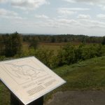
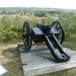
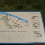
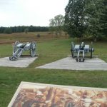
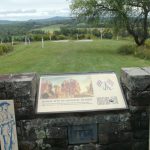
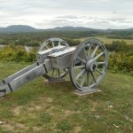
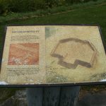
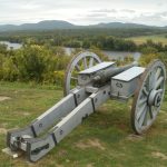
For those who have not visited, the park does an excellent job of laying out the American and British fortification lines with posts. The tops of which are painted either blue (American) or red (British). There are also a number of period-correct cannon mounted on field carriages to help envision the location of artillery batteries. The COVID-19 situation forced the closure of the Visitor’s Center, which has an impressive interpretive area complete with an electronic map that traces troop movements during both the September 19 battle at Freeman’s Farm and the October 7 battle at Bemis Heights. Without the visitor center, however, the importance of the posted fortification lines increases exponentially. So, too are the colorfully painted dioramas explaining the events of each site. One note – the dioramas are showing their age. Many need to be repainted or replaced. They all have buttons that start a recorded topic, but whether they work is hit or miss. The park is showing the strains of inconsistent – or nonexistent – funding.
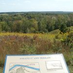
The first stop is an overlook of Freeman’s Farm. The first battle between Burgoyne’s army and Gate’s army occurred here on September 19.
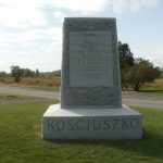
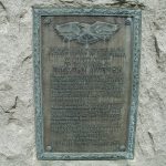
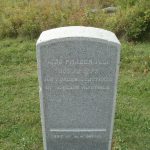
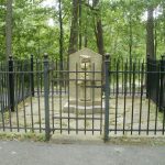
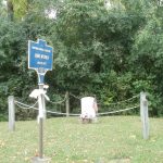
The visit to the tiny Neilsen house and American fortifications never fails to impress. The view is amazing, but the idea that upwards of 15,000 troops manned the extensive lines here is incredible. This may have been the site of the largest concentration of American forces in the entire American Revolution. That said, the highlight for us was the monument to Polish engineer Thaddeus Kosciusko. He chose the site, planned the fortifications and positioned the artillery batteries that won the campaign. He never gets enough credit.
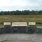
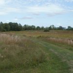
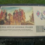
The first battle at Freeman’s Farm is given short shift. The Battle of Bemis Heights, fought on October 7 receives the lion’s share of the interpretive attention. Barber’s Wheatfield, the scene of the primary part of that day’s events, is the highlight. It’s easy to imagine the detached elements of the two armies facing off here. The monument marking the spot where British General Fraser was mortally wounded is profound. It conjures all sorts of thoughts about how far away the shot came from. Was it Timothy Murphy who took the shot, as Schoharie County history and others insist, or one of several other shooters claiming the honor?
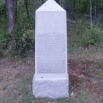
Breymann’s Redoubt is by far the most contemplative. It was a small redoubt, but with much consequence. An assault on nearby Balcarres Redoubt failed, causing the attack on Breymann’s. Benedict Arnold, who was essentially stripped of command by General Gates, charged into battle on his own initiative and formed his own command. He led the assault on Breymann’s and entered it from the rear, where he was wounded in the leg. The taking of this redoubt forced Burgoyne to break camp and begin the retreat north. This was the real turning point of the battle. Up to this point, Arnold was a hero and considered Washington’s best field general. Now, he is remembered by a monument in a grove of trees near the redoubt lines – a boot representing his injured leg. Like all other monuments to Arnold’s acts of bravery prior to his treason at West point, the Boot Monument describes his deeds but deliberately leaves out his name. Was the treason that slowly grew from his convalescence at Philadelphia in 1778 born with the wound to his leg?
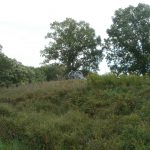
The Great Redoubt is another critical site. From General Fraser’s burial site to the cannon emplacements overlooking the Hudson River, it is a place in which one can feel the frustration and disappointment of Burgoyne’s army. When looking down at the river, its almost as if you are looking through the eyes of Burgoyne or any one of his soldiers; that the river was supposed to show the way to Albany, but instead showed nothing but defeat.
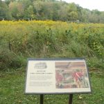
A last stop is shown on the brochure map, but is not an officially numbered stop – a little pull-off after the great Redoubt. A trail descends down off the heights to the flats below. There, the baggage area and artillery park are on one end. The other was a particular interest to Pam – Taylor House, where Baroness Redeisel stayed. We had never taken the trail before, so we saw it all. One word of advice. If you only want to see the Taylor house, take the trail on the left just a few yards from the trailhead at the parking lot. Otherwise, you’re in for a very long walk – the baggage and artillery park sites are on the main trail that bears right. To reach the Taylor House site from there, you must reverse course and take a connecting trail at the base of the heights. None of the Boy Scout logo-adorned trail posts are marked as to where they lead.
All in all – the Saratoga Battlefield is a must-visit destination. Keep your eyes peeled for monuments between stops and bring water on warm days! Expect to spend half a day or more exploring it. There are port-a-pot restrooms at several sites, housed in sheds to be a little more attractive.
While in the neighborhood, take a drive up Route 4 to Fort Edward. In Schuylerville is the Saratoga Monument and the Burgoyne Surrender Site at Fort Hardy park. In Fort Edward, on the west side of U.S. Rte 4 is the original burial site of Jane McCrea, killed nearby by a band of Burgoyne’s native warriors on July 27, 1777. Her murder sparked the rallying cry “Remember Jane McCrea!” and caused many fence-sitters to take up arms against the British invasion.
On our last visit, we had dinner at the Century House on Rte 9 (New Loudon Road) in Latham. Highly recommended! Very professional handling Covid-19 protocols, with outdoor dining available. Excellent, very tasty dinner. Expected higher prices, but was actually reasonable for the high quality of the meal.